Enquire Now for a free site visit – call

Introduction
Buying flood prone land Chennai can create serious problems if you do not check the property carefully before investing. Chennai’s flood history shows why location-level verification matters: the India Meteorological Department records 294.1 mm of rainfall in 24 hours on 2 December 2015, the highest December 24-hour rainfall in its available Chennai record. The Chennai Climate Action Plan also identifies areas vulnerable to different levels of flooding, including 42.36 sq. km facing high-depth flooding under its 25-year return-period scenario. So, how can you identify flood prone land in Chennai before committing your money? By checking the plot’s elevation, drainage, nearby waterbodies, previous flood history and official flood-risk information before finalizing the purchase.
How to Identify Flood-Prone Land in Chennai
Before buying a plot, look beyond the price, road access and documents. Chennai receives its heaviest average rainfall in October and November, with the IMD recording long-term averages of 315.6 mm and 374.4 mm respectively. The city has also experienced extreme events, including 294.1 mm of rain in 24 hours on December 2, 2015. To identify potentially flood-prone land, examine the plot’s elevation, surrounding terrain, nearby waterbodies, drainage channels and previous flooding history. Do not rely only on what a seller or broker says. Visit the location, speak with nearby residents and cross-check available official information before paying an advance or signing the sale agreement.
Check the Plot’s Elevation and Surrounding Terrain
A plot’s height compared with its surroundings can strongly influence how rainwater behaves during heavy rainfall. Start by comparing the plot level with the adjoining road, neighbouring properties and nearby drainage paths. If the plot sits noticeably lower, rainwater may collect there when surrounding areas drain toward it.
During your site visit, check:
- Is the plot lower than the road?
- Does water naturally flow toward the property?
- Are nearby houses built on raised foundations?
- Does the surrounding area show signs of soil filling?
Chennai’s flood-risk planning demonstrates why location matters. The Chennai Climate Action Plan identifies areas vulnerable to flooding under different return-period scenarios. For a serious purchase, consider professional level or elevation verification instead of relying only on visual judgment.
Check Nearby Waterbodies and Drainage Channels
Nearby lakes, canals, rivers and stormwater channels can influence how quickly water moves through an area during intense rainfall. A plot that looks dry during normal weather may still face problems when heavy rain overwhelms local drainage.
Check these features before buying:
- Lakes and ponds: Identify nearby waterbodies and their surrounding drainage routes.
- Canals and channels: Check whether natural or constructed channels pass near the property.
- Stormwater drains: Look for blocked, narrow or poorly maintained drains.
- Road drainage: Check whether rainwater has a clear route away from the plot.
- Low-lying surroundings: Compare the plot with nearby streets and open areas.
This matters in Chennai because extreme rainfall can quickly create drainage pressure. The IMD recorded 246.5 mm in 24 hours in November 2015 and 294.1 mm in December 2015.
Look for Previous Flooding History
Past flooding gives you one of the most useful clues about a plot’s real-world risk. Do not ask only the seller. Talk to residents, shop owners and security staff nearby because they often remember how the street behaved during major rainfall events. For example, if neighbours say “water entered this street during the 2015 floods and remained for several days,” investigate further before proceeding. If residents report that only the road floods while the plot remains dry, ask why and check the plot’s elevation. You can also compare local reports with official rainfall records. Chennai recorded 1,049.3 mm of rainfall during November 2015, while the IMD recorded 294.1 mm in a single day in December 2015. These events show why buyers should examine historical performance rather than judge flood risk from a single dry-weather visit.
Check Official Flood and Waterlogging Information
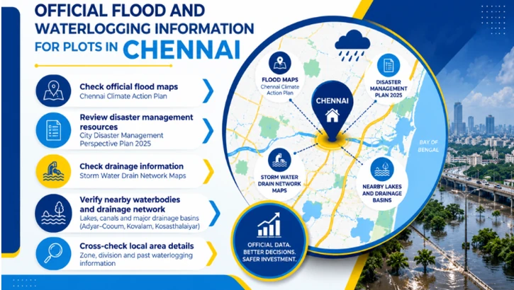
Before buying land, check official flood and waterlogging information instead of relying only on a broker’s claim. Chennai’s flat terrain creates drainage challenges: the Greater Chennai Corporation says the city’s average land level stands at only 2 metres above Mean Sea Level, which contributes to water stagnation during monsoons.
The Chennai Climate Action Plan also maps flood vulnerability across different return periods. Under its 25-year scenario, 42.36 sq. km faces high-depth flooding of more than 5 feet. Check these official resources against the exact plot location, survey details and surrounding roads. This approach gives you stronger evidence before you commit your money.
Use Government Flood Maps and Disaster Management Resources
Government flood maps can help you understand the wider flood risk around a proposed plot. The Chennai Climate Action Plan includes flood-vulnerability maps for 5-, 25-, 50- and 100-year return periods. Under the 25-year scenario, the plan identifies 42.36 sq. km with high-depth flooding above 5 feet, while another 53.22 sq. km falls within the moderate 3–5-foot category.
When checking a plot:
- Locate the property on the relevant flood-risk map.
- Compare its surroundings with mapped vulnerable areas.
- Check the Greater Chennai Corporation’s City Disaster Management Perspective Plan 2025.
- Review official stormwater-drainage information.
Use these resources as an initial risk check, not as a substitute for a site-level assessment.
Check Chennai Corporation and Local Authority Information
The Greater Chennai Corporation (GCC) provides several useful resources for checking local drainage and flood-related conditions. Its website includes Storm Water Drain Network Maps, zone information and disaster-management resources. The Corporation also explains that Chennai’s flat terrain and tidal effects can contribute to flooding and water stagnation during monsoons.
| What to Check | Why It Matters |
|---|---|
| SWD Network Map | Shows nearby stormwater drainage |
| Zone & Division | Identifies the responsible local authority |
| Disaster Management Plan | Provides local risk information |
| Stormwater Drain Department | Helps understand drainage infrastructure |
| Local complaints | Can reveal recurring waterlogging issues |
For example, if your proposed plot sits near a drainage network, check its connection and condition rather than assuming the drain will automatically prevent flooding.
Check Whether the Plot Falls Near a Waterbody or Drainage Network
A plot may look perfectly suitable during dry weather but face serious problems if it sits near a lake, canal, river, marsh or stormwater channel. Start by checking the property’s exact location against nearby water features and drainage routes. The Greater Chennai Corporation divides Chennai into major drainage basins, including the Adyar–Cooum, Kovalam and Kosasthalaiyar basins. For example, if a plot sits close to a lake, check whether surrounding roads drain toward it and whether overflow could affect the property. If a plot lies beside a stormwater channel, check whether the channel remains clear and connects to a larger drainage system. Do not judge risk by distance alone—elevation, drainage capacity and the local terrain also matter.
Visit the Plot Before Buying
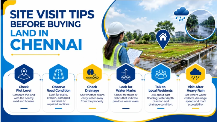
Never finalise a plot based only on online photos, documents or a broker’s explanation. Visit the property in person and examine how the site connects with surrounding roads, drains and low-lying areas. Chennai receives substantial rainfall during the northeast monsoon, with October and November averaging 315.6 mm and 374.4 mm respectively, according to the India Meteorological Department. A physical inspection can reveal warning signs that property listings rarely mention. Walk around the plot, check nearby streets and observe drainage points. If possible, visit at different times and weather conditions. Take photographs, note the road and plot levels, and compare your observations with official flood information before making your purchase decision.
What to Observe During a Site Visit
During your site visit, look beyond the plot boundaries. Examine the entire surrounding area because water does not follow property lines. Chennai’s stormwater network covers thousands of kilometres of drains, and local drainage conditions can vary significantly between streets.
Check these points carefully:
- Plot level: Compare the land with the nearby road and houses.
- Road condition: Look for stains, erosion, damaged surfaces or repaired sections.
- Drainage: Check whether drains carry water away from the property.
- Water marks: Look for stains or debris that indicate previous water levels.
- Neighbouring land: Check whether nearby vacant plots collect rainwater.
- Access: Consider whether vehicles can reach the property during heavy rain.
Take photos and record your observations. If the plot appears significantly lower than its surroundings, ask a qualified professional to check the site levels before you proceed.
Talk to People Living Near the Property
Local residents can provide practical information that maps and advertisements may not reveal. Speak with people who have lived in the area through several monsoon seasons. Ask specific questions instead of simply asking, “Does this area flood?” Their answers can help you understand the frequency, depth and duration of waterlogging.
Ask nearby residents:
- Has this street flooded during previous heavy rains?
- How high does the water usually rise?
- How long does water remain after rainfall stops?
- Does water enter nearby houses or shops?
- Which direction does rainwater flow?
- Does the road become difficult for cars or two-wheelers?
- Has drainage improved after previous floods?
- Have nearby plots required soil filling or raising?
For example, if several independent residents say the same street regularly holds water for hours, treat that information as an important warning sign and investigate further.
Visit the Area After Heavy Rain if Possible
A visit immediately after heavy rain can reveal conditions that remain invisible during dry weather. You can see where water collects, how quickly drains move water and whether the plot remains accessible. Chennai recorded 294.1 mm of rainfall in 24 hours on December 2, 2015, showing how quickly extreme rainfall can test local drainage systems. For example, imagine two nearby plots. Plot A sits slightly above the road and remains dry while water flows through the drain. Plot B sits below road level and collects water near its entrance. That difference matters even if both plots look identical on a sunny day.
If heavy rain occurs before your purchase, visit the location and observe:
- Water depth around the plot
- Drainage speed
- Road accessibility
- Water entering neighbouring properties
- Any overflow from nearby drains or channels
This real-world check can strengthen your flood-risk assessment.
Check the Plot’s Documents and Development Details
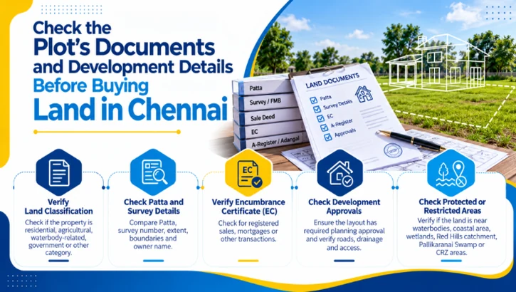
Before buying a plot, check both the land documents and development approvals. Do not rely only on the seller’s words or a brochure. Match the survey number, land extent, owner name, boundaries, and classification across the documents.
Tamil Nadu government services include Patta, Adangal, EC, certified copies, and other revenue records for property verification. Also check whether the layout has the required planning approval and whether roads, drainage, and access match the approved plan. These checks can reveal ownership issues, incorrect survey details, unapproved development, or drainage-related concerns before you invest.
Verify the Land Classification
Check the land classification before you pay an advance. Revenue records can show whether the property falls under residential, agricultural, waterbody-related, government, or other categories. Compare the Patta, A-Register, Adangal, FMB sketch, and sale deed instead of checking only one document. Tamil Nadu government procedures also require revenue records such as Patta, A-Register, FMB or Town Survey records for certain land-related approvals.
For flood-risk checking, pay special attention to records connected with water channels, tanks, lakes, marshes, or drainage paths. A plot may look suitable for construction but still face restrictions. For example, land connected to a waterbody or drainage channel can create serious development concerns. Ask the seller to provide the latest records and verify them with the appropriate Revenue or planning authority.
Check Patta, Survey Details and Encumbrance Records
Check whether the seller’s documents tell the same story about the property. Compare the Patta, survey number, subdivision number, extent, boundaries, and owner name. Then check the Encumbrance Certificate (EC) for registered transactions affecting the property. Tamil Nadu provides online services for EC issuance and EC downloads through its e-governance system.
| Document | What to Check |
|---|---|
| Patta | Owner name, survey number and land details |
| Survey/FMB | Boundaries, measurements and subdivision |
| Sale Deed | Seller ownership and property description |
| EC | Registered sales, mortgages or other transactions |
| A-Register/Adangal | Land classification and revenue details |
If any detail differs, stop and clarify it with a qualified property lawyer or the concerned authority before paying.
Check Whether the Land Is Near a Protected or Restricted Area
A plot can face development restrictions because of its location near a waterbody, coastal area, wetland, catchment, protected zone, or other regulated area. Chennai planning documents identify areas such as Pallikaranai Swamp, Red Hills catchment, aquifer recharge areas, and Coastal Regulation Zone (CRZ) areas with specific development controls. Tamil Nadu’s coastal authority also classifies CRZ areas and identifies ecologically sensitive locations such as mangroves, sand dunes, wetlands, and wildlife habitats.
Examples:
- A plot near Pallikaranai Swamp may face development restrictions.
- A coastal plot may fall under CRZ regulations.
- Land near Red Hills catchment may require additional checks.
- A plot beside a water channel may need verification before construction.
Always check the exact survey number against the applicable planning and environmental records.
Conclusion
Buying a plot is a major investment, so checking flood risk before making a decision can save you from costly problems later. Don’t judge a property only by its location, price, or appearance. Check the plot’s elevation, nearby waterbodies and drainage channels, previous flooding history, official flood information, land classification, Patta, survey details, EC, and development approvals. A physical site visit and conversations with nearby residents can also reveal problems that documents may not show. If you are looking for plots for sale in Chennai, take time to verify every detail and choose a property that fits your needs and has a clear development path. Contact us today to explore suitable plots and get guidance before you buy.
Frequently Asked Questions:
1. How can I check whether a plot is flood-prone before buying?
Check elevation, drainage, nearby waterbodies, and previous flood history before buying.
2. Is every low-lying plot in Chennai flood-prone?
No. Flood risk depends on elevation, drainage, terrain, and local flood history.
3. How do I check the flood history of a plot?
Talk to nearby residents and check official flood and waterlogging records.
4. Can nearby lakes or canals increase flood risk?
Yes. Nearby waterbodies and drainage channels can increase flooding during heavy rain.
5. Should I check the plot’s elevation before buying?
Yes. Compare the plot level with the road and surrounding properties.
6. Can government flood maps identify flood-prone land?
Yes. Official flood maps can help identify areas with higher flood vulnerability.
7. What documents should I check before buying a plot?
Check Patta, sale deed, survey details, FMB, EC, land classification, and approvals.
8. Does a clear Patta mean the plot is flood-safe?
No. Patta does not confirm flood safety or good drainage conditions.
9. Should I visit the plot after heavy rain?
Yes. It can reveal waterlogging, drainage problems, and road accessibility issues.
10. What are the warning signs of flood-prone land?
Standing water, poor drainage, low plot levels, and repeated local flooding are key warning signs.